Dixie Highway
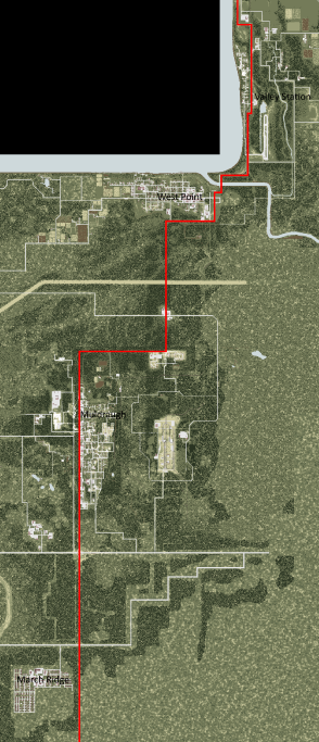
Dixie Highway or Dixie Hwy, also known as Route 31W, is a major road in Project Zomboid, and the only one mentioned in-game. The highway runs through the center of Knox Country, starting at the Louisville border camp, running down through Valley Station, over a bridge and past West Point, down through a small intersection and then going past Dixie Mobile Park, heading down through Muldraugh and then continues going down close to March Ridge in the south before leaving the map.
Overview
The Dixie Highway is a large highway that covers a large portion of the map, cutting through or coming close to most major locations in the game,as well as having a large amount of room to swerve to dodge obstacles, allowing for cars to travel at great speeds in mainly open road conditions. The only parts of the road to worry about is the bridge near West Point, which is covered in car wrecks, and where the road cuts through Muldraugh, where it is often heavily populated by zombies. While the road itself contains almost nothing of value other than car parts, it borders a lot of locations that serve as great locations to loot.
Getting to and from the highway is relatively easy from all locations. The highway is next to or goes through all locations but Riverside, Fallas Lake and Rosewood, but getting to these locations from the highway is still straightforward.To get to Riverside, you can enter West Point and follow the Ohio River from there, and to get to Rosewood you can simply go to the large intersection near the bottom of Muldraugh and follow the unnamed highway until you can enter the top of the town. Fallas lake is the hardest location to get to, but you can use the road that goes near the Muldraugh construction site and follow it until you reach the bottom of the town.
Businesses and landmarks
While most of the locations don't lie on the actual highway, they are very close and can be seen from the highway or accessed extremely easily.
Valley Station
| Business | Type | Coordinates |
|---|---|---|
| Bus station | Transportation | 12731x5770 |
| Diner | Restaurant | 12740x5713 |
| Small convenience store | Convenience store | 12625x5326 |
| Ruby Gas | Gas station | 12738x5039 |
| Beer and Liquor | Liquor store | 12717x5060 |
West Point
| Business | Type | Coordinates |
|---|---|---|
| Fossoil | Gas station | 12070x7142 |
Dixie
| Business | Type | Coordinates |
|---|---|---|
| Barg-N-Clothes | Clothing | 11599x8259 |
| Diner | Restaurant | 11462x8809 |
| Food Market | Grocery store | 11662x8793 |
| Gas station | Gas station | 11506x8840 |
| Gas 2 Go | Gas station | 11592x8306 |
| Coin Op Laundromat | Laundromat | 11681x8822 |
| Nolan's Used Cars | Car dealership | 11687x8367 |
| Spiffo's | Restaurant | 11663x8302 |
Muldraugh
Influence
Dixie Highway is based off of its real-world counterpart of the same name and location. It begins in Louisville, KY in the north, and ends at Nashville, TN.


