

March Ridge
The Game World > Locations > March Ridge
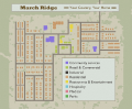
March Ridge

Isometric view of March Ridge
General
Type
Town
Location
Coordinates
Map

Map location
March Ridge is a small gated military town in the state of Kentucky, in an area known as Knox Country, forming part of Planned features, an upcoming military base. March Ridge is located south of the Ohio River, Muldraugh, West Point, Planned features, Valley Station, Louisville, and south east of Rosewood with Dixie Hwy (Route 31W) running on the east side.
Businesses and Landmarks
Food & Drink
| Business | Type | Coordinates |
|---|---|---|
| Bar | Bar | 10172x12674 |
| Mendy's Eatery | Restaurant | 10130x12754 |
| Go 2 Bread | Bakery | 10073x12802 |
| Restaurant | Restaurant | 10103x12745 |
| Seahorse Coffee | Cafe | 10183x12807 |
Hair & Beauty
| Business | Type | Coordinates |
|---|---|---|
| Hair Salon | Hair Salon | 10183x12817 |
Leisure
| Business | Type | Coordinates |
|---|---|---|
| Park | Park | 10017x12779 10297x12778 |
| Playground | Park | 9885x13025 |
Retail & Stores
| Business | Type | Coordinates |
|---|---|---|
| Filigree Fashions | Bakery | 10073x12816 |
| Hit Vids! | Bakery | 10164x12733 |
| Nourish Food Mart | Bakery | 10116x12787 |
| Pharmahug | Bakery | 10143x12752 |
Services
| Business | Type | Coordinates |
|---|---|---|
| Church | Church | 10328x12789 |
| March Ridge Entrance Gate Booth | Entrance Gate Booth | 10363x12379 |
| Family Medical Center | Clinic | 10159x12753 |
| March Ridge Community Center | Laundromat | 10034x12733 |
| March Ridge School | Laundromat | 10000x12656 |
| Knox Military Apartments | Laundromat | 10070x12624 |
| Post Office | Post Office | 10108x12714 |
Utilities
| Business | Type | Coordinates |
|---|---|---|
| Filling Station | Filling Station | 10142x12786 |
| Laundromat | Laundromat | 10183x12782 |
| Superklean | Laundromat | 10184x12731 |
Other
| Business | Type | Coordinates |
|---|---|---|
| ABCDriving School | Storage | 10073x12784 |
| Office | Storage | 10183x12791 |
| Star E Plex Cinema | Storage | 10173x12643 |
| Stor A Max | Storage | 10346x12404 |
| United Shipping Logistics | Storage | 10073x12776 |
Gallery
The in-game tourist map of March Ridge

In-game March Ridge
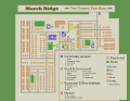
Custom tourist map of March Ridge
