

Valley Station: Difference between revisions
m (Vaileasys moved page Valley Station to Valley Station) |
mNo edit summary |
||
| Line 15: | Line 15: | ||
| coordinates = 6435x5282 | | coordinates = 6435x5282 | ||
}} | }} | ||
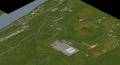
'''Valley Station''' is a large area of land spreading from the Ohio River to the densely forested area to the east. It is at the furthermost outskirts of [[ | '''Valley Station''' is a large area of land spreading from the Ohio River to the densely forested area to the east. It is at the furthermost outskirts of [[Louisville, KY|Louisville]], with the majority of the land being designated farmland. | ||
==Businesses and landmarks== | ==Businesses and landmarks== | ||
Revision as of 18:07, 2 May 2019

Valley Station is a large area of land spreading from the Ohio River to the densely forested area to the east. It is at the furthermost outskirts of Louisville, with the majority of the land being designated farmland.
Businesses and landmarks
- Academy
- Burger Shop
- Church
- Construction sites
- Destroyed Cabin
- Diner
- Food Market
- Gas Station
- Gas-2-Go
- Knox Bank
- Racetrack
- Shooting Range
- Dock
- Shop
- Bus Station
- Zippee Mart
- StarEPlex Cinema
- Crossroads Mall
- Yummmers Bar
- Pile'o'Crepe Pancake House
- Churus-R-Us
- Zippee Market
- Knob Creek Hunting Lodge
- Guns-a-BlazINN
Gallery
In-game Valley Station
