

Doe Valley

Doe Valley is the largest area in Project Zomboid, covering a majority of space in the western part of the Knox Country map. The area of Doe Valley is almost entirely covered by farmlands and small farmhouses, going as far as the western map border, encompassing Fallas Lake, with Rosewood bordering the south and Riverside up north of the Valley. You will most likely pass through this region while travelling between, from or to these major townships.
Overview
Doe Valley is the name of the broadest stretch of land on the Knox Country map, with most of the area subsisting of vast farmland with an odd house or a line of warehouses. However, there are two small villages on the Valley that house most of the area's locations of interest, one unnamed pit stop in the western corner of the Valley and Fallas Lake to the north. There are a few buildings that may hold extremely valuable and large amounts of loot such as the Jamieton Army Surplus. There are also a handful of warehouses which contain crates with huge amounts of vegetable and fruit sacks, although these crops are perishable and will rot within the first week. Regardless, this makes these warehouses a great source of compost for farming, or food if you can get to them in time or preserve them.
Due to zombie population throughout the Valley being quite low, Doe Valley is generally a safe place, making any of the small groups of houses or solo houses located in the Valley a good place to settle in. Regardless, there are a few places within Doe Valley that have a decent zombie population, namely Fallas Lake, and the village to the west of the valley. While the western corner contains the army surplus store, Fallas Lake has far more residential and commercial facilities.
Districts
Doe Valley can be divided into four districts; Centre, West, Fallas Lake (North) and East.
Center
The center of Doe Valley is one of the larger parts of the Valley. Covering a large amount of area south of Fallas Lake, and with Rosewood to the south, it is covered almost entirely by farmland. While being a massive chunk of space, it has surprisingly low amounts of anything notable, with the only buildings being lone houses and the odd warehouse. However, due to the low amount of zombies in the area, it can make for a very safe base location, but the low amount of resources and lack of any natural water sources means you'll be taking loot runs a lot more than usual should you wish to live here.
West
Perhaps the most interesting part of Doe Valley, the western part is home to the small village and a group of buildings on the side of the road, both of which are more than worth visiting and are the main attraction of Doe Valley as a whole. The small village is home to most of the commercial buildings, namely Jamieton Army Surplus, which contains a huge amount of survival supplies, clothes, and firearms. The other small roadside area has a few houses and a Diner, as well as a Camping store and a Gun store. While this area has the highest population of zombies within Doe Valley, it is still rural and relatively moderate, making the western district a valuable part of Doe Valley well worth visiting.
Fallas Lake
Fallas Lake is a named town in the northern district of Doe Valley. It has a lot of buildings and other locations of interest which can be found in its article. Up north of the Fallas Lake, Doe Valley's northernmost part consists of two smaller lakes and bunch of small houses next to some wheat farms.
East
The eastern district of Doe Valley is perhaps the least interesting. Consisting of both forest and farmland, it is far smaller than both the west and centre districts and contains far less structures overall, with the only notable location being the Pony Roam-O, a small equestrian center, making this area bad for looting. However, The eastern district may make for a good rural base location, as the houses there are secluded, there are nearby water sources, and the Ohio River makes for a good fishing spot should you choose to live there.
Businesses
Restaraunts & Entertainment
| Business | Type | Coordinates |
|---|---|---|
| Restaurant (Fallas Lake) | Restaurant | 5544x9661 |
| Burgers | Restaurant/cafe | 7234x8202 |
| Diner | Diner | 3701x8460 |
| Restaraunt | Restaraunt | 5544x9660 |
| Ice cream parlor | Ice cream parlor | 7133x8977 |
| The Horseshoe | Bar | 7246x8522 |
| Pony Roam-O | Park/leisure | 8563x8515 |
| Camp Busy Beaver | Summer Camp | 5004x7993 |
Retail & Commercial
| Business | Type | Coordinates |
|---|---|---|
| Clothing store | Clothing store | 5497x9564 |
| The Good Book | Book store | 7256x8431 |
| Camping store | Camping supply store | 3800x8549 |
| Gun store | Gun store | 3806x8513 |
| Food Markets | Grocery store | 5459x9584 7251x8283 |
| General store (Fallas Lake) | General store | 7293x8254 |
| Grocery stalls | Grocery stall | 7146x8989 8495x8545 |
| E.P. Tools | Hardware Store | 7255x8231 |
| Farming & Rural Supply | Farming store | 7252x8321 |
| Jamieton Army Surplus | Military surplus store | 5464x9511 |
| Coin Op Laundromat | Laundromat | 5472x9680 |
| Laundr-o-max | Laundromat | 7260x8499 |
| Gas station | Gas station | 5473x9709 |
| Gas N More | Gas station | 3692x8495 |
| County Offices | Office building | 5435x9681 |
Community Services
| Business | Type | Coordinates |
|---|---|---|
| Deerhead Lake Park Ranger | Camping lodge | 4674x8596 |
| Small Churches | Religious building | 5872x9423 |
| Assembly hall (Fallas Lake) | Social center | 7414x8385 |
| Police Station (Fallas Lake) | Police station | 7252x8378 |
| Church | Religious building | 7387x8351 |
Medical
| Business | Type | Coordinates |
|---|---|---|
| Doctor's office | Medical clinic | 5497x9582 |
| Doctor's office (Fallas Lake) | Medical clinic | 7295x8388 |
Industrial
| Business | Type | Coordinates |
|---|---|---|
| Lenny's Car Repair | Automobile repair shop | 5466x9658 |
| Produce warehouses | Produce storage | 6773x10002 5890x9860 6565x9325 6560x8945 |
Strategy
- Perhaps being the safest area in the entirety of Knox Country, except the wilderness itself, Doe Valley is a perfect location for those who seek peace and safety. The vast farmlands and open fields ensures for players to spot zombies from miles afar. Almost all of the Doe Valley is rural, and these rural areas have very low zombie density. There are few spots that have a potential to be a good safehouse, with woods on the one side for log gathering, foraging, and open fields on the other side for farming. Couple water sources such as small lakes, ponds, and a river can be found on the north and west of the Valley, which can be visited & camped for fishing. It is the place for survivalist's heaven, if you are into this rustic lifestyle.
- If players choose to make a base in Doe Valley, they must first ensure that they have brought everything they need from other towns: This means every basic necessity that rarely spawns in Doe Valley for a character to survive or to live comfortably. Most notably these do include; skill books, vehicle parts, both ranged and melee weapons, spare winter clothing in winter, generator with scrap electronics, canned food and literature.
- There are various warehouses with different containment purposes are scattered around the Valley which are great locations for quality loot.
- Running out of gas or engine stop in the middle of nowhere is a serious danger that players may face, unless you are lucky enough to be stranded near a village or a house with one car in the garage. Therefore, precautions should be taken before every car trip inside Doe Valley.
Gallery
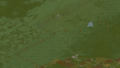
In-game Doe Valley, west
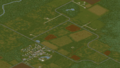
In-game Doe Valley, north
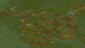
In-game Doe Valley, center
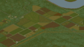
In-game Doe Valley, east


