

Knox Country: Difference between revisions
m (rm .) |
|||
| (119 intermediate revisions by 21 users not shown) | |||
| Line 1: | Line 1: | ||
{{ | {{Header|Project Zomboid|World|Locations}} | ||
[[File:Pzmap-comparison.jpg|thumb|link={{filepath:Pzmap-comparison.jpg}}|Map of Project Zomboid overlayed on top of the real world photos of the area | {{Page version|41.78.16}} | ||
[[File: | [[File:Pzmap-comparison.jpg|thumb|link={{filepath:Pzmap-comparison.jpg}}|Map of Project Zomboid overlayed on top of the real world photos of the area]] | ||
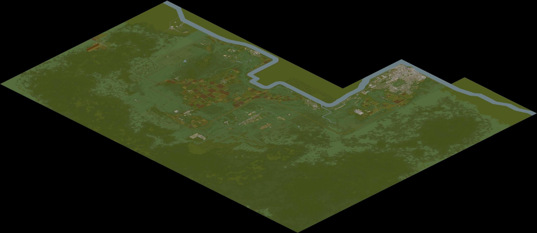
{{About|the current map for Project Zomboid|the map prior to [[Version history#1|0.2.0r]]| | [[File:Pzmap-map.png|thumb|link={{filepath:Pzmap-map.png}}|A picture of the in-game Knox Country map]] | ||
''Thanks to the efforts of [[Blindcoder]], a complete and [https://map.projectzomboid.com/ fully interactive map] has been made available to the community. You can assist in his efforts on expanding the project by visiting the [ | {{About|the current map for Project Zomboid|the map prior to [[Version history#1|0.2.0r]]|Knox County}} | ||
''Thanks to the efforts of [[User:Blindcoder|Blindcoder]], a complete and [https://map.projectzomboid.com/ fully interactive map] has been made available to the community. You can assist in his efforts on expanding the project by visiting the [https://theindiestone.com/forums/index.php?/topic/78-project-zomboid-map-project/ thread on the forums]. | |||
'''Knox Country''' (formerly known as '''Knox County''') is a partially fictional area where the events of [[Project Zomboid]] take place. The map is heavily based off of the real-world area around [[Wikipedia:Fort Knox|Fort Knox]] and [[Wikipedia:Louisville, Kentucky|Louisville]] in northern [[Wikipedia:Kentucky|Kentucky, USA]]. Knox Country contains recreations of the real-world [[Muldraugh]], [[West Point]], [[Dixie]], [[March Ridge]], [[Fallas Lake]] (formerly known as Ekron), [[Valley Station]], and [[Louisville]]. There are also some entirely fictional towns within Project Zomboid, including [[Rosewood]] and [[Riverside]]. | |||
Knox Country was just your standard, peaceful countryside region until an outbreak of a mysterious illness that reanimates infected persons into [[zombie]]s, later coined the [[Knox Infection]]. Fearing further spread, The U.S Government designated Knox Country as an exclusion zone, quarantined the area and prevented any information from reaching the outside world. | |||
==Muldraugh== | |||
{{Main|Muldraugh}}[[File:Muldraugh.png|thumb|link={{filepath:Muldraugh.png}}|An isometric view of Muldraugh]] | |||
One of the more moderately-sized towns in Knox Country, made up mostly of residential and industrial buildings. Many of the residents live in poorer quality housing than residents in other towns. | |||
Some points of interest in town include: | |||
<div style="column-count: 3; -moz-column-count: 3; -webkit-column-count: 3; width: 800px;"> | |||
*[[Cortman Medical]] | |||
*[[McCoy Logging Co.]] | |||
*[[Muldraugh Elementary|Muldraugh Elementary School]] | |||
*[[Police station]] | |||
*[[The Rusty Rifle]] | |||
*[[Sunstar Motel]] | |||
</div> | |||
{{Clear}} | |||
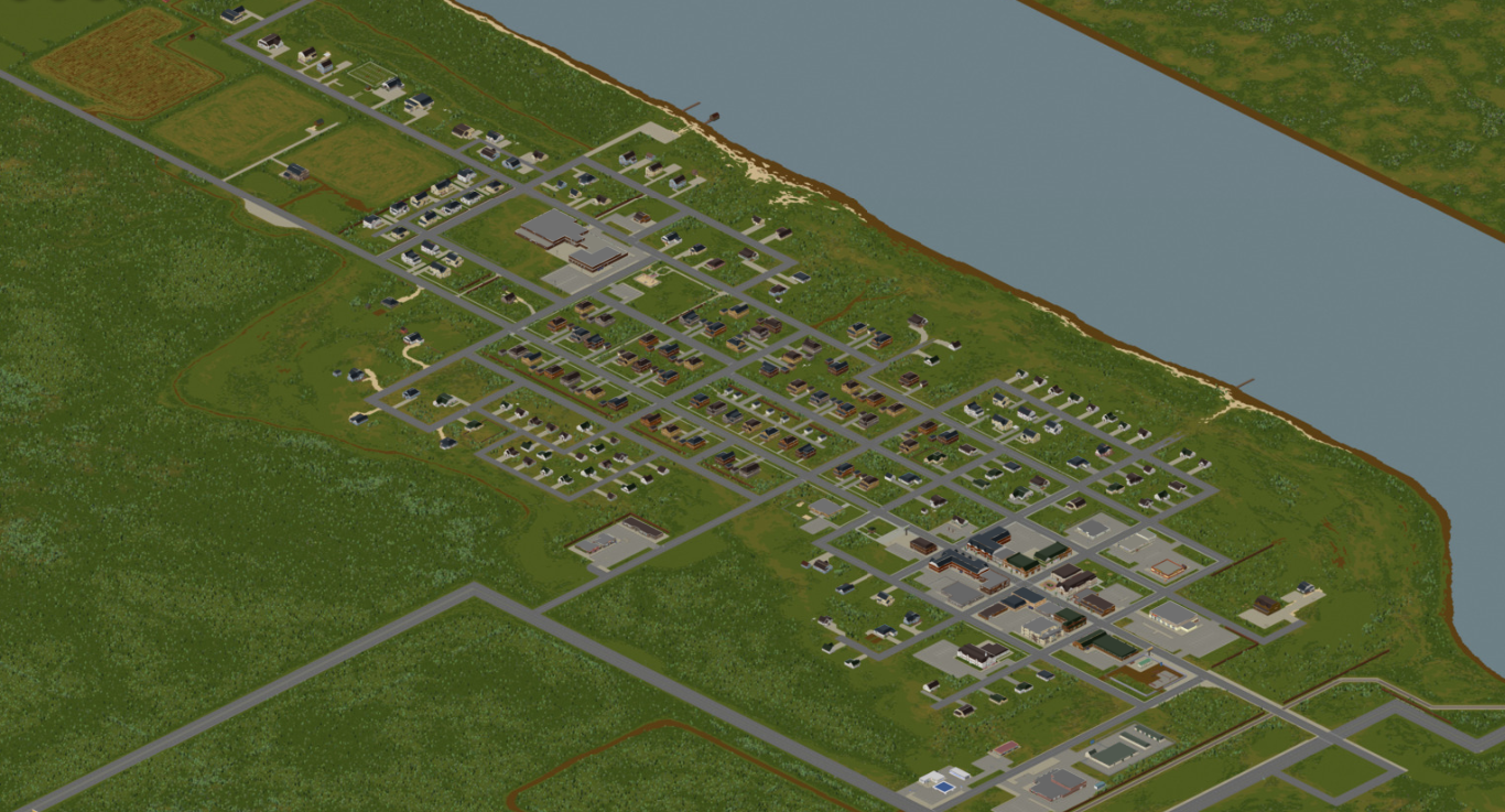
==Riverside== | |||
{{Main|Riverside}}[[File:Riverside.png|thumb|link={{filepath:Riverside.png}}|An isometric view of Riverside]] | |||
A wealthier town situated on the Ohio River in the north-west corner of Knox Country. Features a gated community with a country club. | |||
Some points of interest in town include: | |||
<div style="column-count: 3; -moz-column-count: 3; -webkit-column-count: 3; width: 800px;"> | |||
*[[Wrecking yard]] | |||
*[[West Maple Country Club]] | |||
[[ | *[[Pharmahug]] | ||
*[[Police station]] | |||
*[[Gated Community]] | |||
*[[Riverside Suites]] | |||
*[[Riverside School]] | |||
*[[Scenic Grove Mobile Park]] | |||
</div> | |||
{{Clear}} | |||
==Rosewood== | |||
* | {{Main|Rosewood}}[[File:Rosewood.png|thumb|link={{filepath:Rosewood.png}}|An isometric view of Rosewood]] | ||
* | A newly-developed town with compact services and a nearby prison. | ||
* | |||
* | Some points of interest in town include: | ||
* | <div style="column-count: 3; -moz-column-count: 3; -webkit-column-count: 3; width: 800px;"> | ||
* | *[[Econo-Rooms]] | ||
* | *[[Kentucky State Prison]] | ||
* | *[[Kentucky Court of Justice]] | ||
*[[Police station]] | |||
*[[Rosewood Fire Department]] | |||
*[[Rosewood Medical]] | |||
*[[Elementary school (Rosewood)]] | |||
* | *[[Onyx Drive-In Theater]] | ||
* | </div> | ||
*Police station | {{Clear}} | ||
* | |||
* | ==West Point== | ||
{{Main|West Point}}[[File:West Point.png|thumb|link={{filepath:West Point.png}}|An isometric view of West Point]] | |||
A large river-bound town north of Muldraugh with a clear town center and a close proximity to the Ohio River crossings. | |||
Some points of interest in town include: | |||
<div style="column-count: 3; -moz-column-count: 3; -webkit-column-count: 3; width: 800px;"> | |||
*[[Twiggy's]] | |||
*Hardware store | |||
*[[School (West Point)]] | |||
*[[Police station]] | |||
*[[West Point Gun Range and Hunting Center]] | |||
*[[Pharmahug]] | |||
</div> | |||
{{Clear}} | |||
==Valley Station== | |||
{{Main|Valley Station}}[[File:Valley Station.png|thumb|link={{filepath:Valley Station.png}}|An isometric view of Valley Station]] | |||
A sparse town across the Ohio River whose main attraction is its sizeable [[Crossroads Mall|mall]]. | |||
Some points of interest in town include: | |||
<div style="column-count: 3; -moz-column-count: 3; -webkit-column-count: 3; width: 800px;"> | |||
*[[Crossroads Mall]] | |||
*[[Drag Racing]] | |||
*[[StarEPlex]] | |||
*[[Knob Creek Hunting Lodge]] | |||
</div> | |||
{{Clear}} | |||
== | ==Louisville== | ||
{{Main| | {{Main|Louisville}}[[File:Louisville.png|thumb|link={{filepath:Louisville.png}}|An isometric view of Louisville]] | ||
[[File: | A large, densely populated metropolis across the Ohio River on the border of the Knox Exclusion Zone. Later designated part of the exclusion zone after being overrun. Most of the city's borders are still sealed off by fences constructed during the [[Knox Event]]. | ||
Some points of interest in the city include: | |||
<div style="column-count: 3; -moz-column-count: 3; -webkit-column-count: 3; width: 800px;"> | |||
* | *[[LBMW - Kentucky Radio]] | ||
* | *[[LBMW Network]] | ||
* | *[[St. Peregrin Hospital]] | ||
* | *[[Louisville border camp]] | ||
* | *[[Louisville Police Department]] | ||
* | *[[Louisville Expo Center]] | ||
* | *[[Spiffo's]] Headquarters | ||
* | *[[Art Gallery of Louisville]] | ||
* | *[[Fossoil Refinery]] | ||
* | *[[Ready Prep Army Issue Surplus]] | ||
* | *[[Louisville General Hospital]] | ||
* | *[[Louisville Fire Department]] | ||
* | *[[Louisville Train Station]] | ||
* | *[[Louisville State University]] | ||
* | *[[Medical Center]] | ||
* | *[[The Grand Ohio Mall]] | ||
* | *[[Fossoil Field]] | ||
* | *[[Triple-N]] | ||
</div> | |||
{{Clear}} | |||
== | ==March Ridge== | ||
{{Main| | {{Main|March Ridge}}[[File:March Ridge.png|thumb|link={{filepath:March Ridge.png}}|An isometric view of March Ridge]] | ||
[[File: | A gated military settlement made up of tenement buildings and surrounded by forest. | ||
A | |||
Some points of interest in town include: | |||
<div style="column-count: 3; -moz-column-count: 3; -webkit-column-count: 3; width: 800px;"> | |||
*[[Knox Military Apartments]] | |||
*[[March Ridge Community Center]] | |||
*[[Family Medical Center]] | |||
*[[Pharmahug]] | |||
*[[March Ridge School]] | |||
*[[StarEPlex]] cinema | |||
</div> | |||
{{Clear}} | |||
*Knox | |||
* | |||
* | |||
* | |||
* | |||
*StarEPlex | |||
== | ==Fallas Lake== | ||
{{Main| | {{Main|Fallas Lake}}[[File:Fallas Lake.png|thumb|An isometric view of Fallas Lake]] | ||
[[File: | A rural town surrounded by farmland in the center of Knox Country. Features an oddly shaped lake. | ||
= | Points of interest in this town include: | ||
<div style="column-count: 3; -moz-column-count: 3; -webkit-column-count: 3; width: 800px;"> | |||
*[[Farming & Rural Supply]] | |||
[[ | *Doctor's office | ||
*[[Police station]] | |||
*Town hall | |||
*[[E.P. Tools]] | |||
* | </div> | ||
{{Clear}} | |||
* | |||
* | |||
* | |||
==Dixie== | ==Dixie Mobile Park== | ||
{{Main|Dixie}} | {{Main|Dixie Mobile Park}} | ||
[[File:Dixie.png|thumb|link={{filepath:Dixie.png}}| | [[File:Dixie.png|thumb|link={{filepath:Dixie.png}}|An isometric view of Dixie]] | ||
A trailer park which takes its name from the [[Dixie Highway]] on which it lies. | |||
Points of interest in this settlement include: | |||
<div style="column-count: 3; -moz-column-count: 3; -webkit-column-count: 3; width: 800px;"> | |||
*Food Market | *[[Food Market]] | ||
*Diner | *[[Diner]] | ||
*Gas | *[[Gas station]] | ||
*Laundromat | *[[Laundromat]] | ||
*Barg- | *[[Barg-N-Clothes]] | ||
*Gas 2 Go | *[[Gas station#Gas 2 Go|Gas 2 Go]] | ||
*Spiffo's | *[[Spiffo's]] | ||
*Nolan's Used Cars | *[[Nolan's Used Cars]] | ||
</div> | |||
{{Clear}} | |||
== | ==Scenic Grove Mobile Park== | ||
{{Main| | {{Main|Scenic Grove Mobile Park}} | ||
[[File: | [[File:Project Zomboid Scenic Grove.png|thumb|An isometric view of Scenic Grove Mobile Park]] | ||
The Scenic Grove Mobile Park is a trailer park near [[Riverside]]. It also includes a small roadside rest stop. | |||
* | <div style="column-count: 3; -moz-column-count: 3; -webkit-column-count: 3; width: 800px;"> | ||
*[[Al's Autoshop]] | |||
*[[Diner]] | |||
*[[Gas N More]] | |||
* | *[[Self Storage]] | ||
* | </div> | ||
{{Clear}} | |||
*Storage | |||
== | ==Doe Valley== | ||
[[File: | {{Main|Doe Valley}} | ||
[[File:Screenshot 2023-11-01 10.29.09 AM.png|thumb|link={{filepath:Screenshot 2023-11-01 10.29.09 AM.png}}|An isometric view of Doe Valley]] | |||
* | Doe Valley is a large area of Knox Country, being mostly farmland, small houses, and produce warehouses. There are low to no POI's in Doe Valley. Inside Doe Valley, there is a seperate town, that town being called "Jamieton". Doe Valley also encompasses [[Fallas Lake]]. | ||
* | <div style="column-count: 3; -moz-column-count: 3; -webkit-column-count: 3; width: 800px;"> | ||
* | *[[Jamieton Army Surplus]] | ||
*[[Deerhead Lake Park Ranger]] | |||
*[[Lenny's Car Repair]] | |||
*[[Pony Roam-O]] | |||
*[[County Offices]] | |||
</div> | |||
{{Clear}} | |||
*Pony Roam-O | |||
* | |||
== | ==Abandoned town== | ||
{{Main|Abandoned town}} | |||
[[File:Abandonedtown.png|thumb|An isometric view of the abandoned town]] | |||
The abandoned town, nicknamed ''Tanglewood'' by the community, is a dilapidated town, with a large factory nearby. All the houses and businesses are abandoned and in a very poor state except for a single home, which that house could be called the "trapper's house". | |||
*[[CGE Corp]] | |||
*[[Trapper's house]] | |||
{{Clear}} | |||
== | ==Fort Knox== | ||
[[File:Welcome to fort knox.png|thumb|Fort Knox sign available in the game files]] | |||
[[File: | {{Future}} | ||
Fort Knox is a location that is supposed to be added in a future patch, close to the release. | |||
{{Clear}} | |||
==Trivia== | |||
*Knox Country was previously called [[Knox County]], which was renamed in 2013 after the original map was scrapped and remade. | |||
==See also== | ==See also== | ||
*[[Knox County]] | *[[Knox County]] | ||
*[[House In The Woods ( | *[[House In The Woods (challenge)]] | ||
*[[You Have One Day ( | *[[You Have One Day (challenge)]] | ||
*[[Kingsmouth ( | *[[Kingsmouth (challenge)]] | ||
*[[Map]] | *[[Map]] | ||
*[[Mapping]] | *[[Mapping]] | ||
{{Navbox regions}} | |||
Latest revision as of 21:05, 1 May 2024
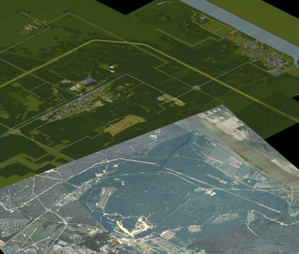
 This article is about the current map for Project Zomboid. For the map prior to 0.2.0r, see Knox County.
Thanks to the efforts of Blindcoder, a complete and fully interactive map has been made available to the community. You can assist in his efforts on expanding the project by visiting the thread on the forums.
Knox Country (formerly known as Knox County) is a partially fictional area where the events of Project Zomboid take place. The map is heavily based off of the real-world area around Fort Knox and Louisville in northern Kentucky, USA. Knox Country contains recreations of the real-world Muldraugh, West Point, Dixie Mobile Park, March Ridge, Fallas Lake (formerly known as Ekron), Valley Station, and Louisville. There are also some entirely fictional towns within Project Zomboid, including Rosewood and Riverside.
Knox Country was just your standard, peaceful countryside region until an outbreak of a mysterious illness that reanimates infected persons into zombies, later coined the Knox Infection. Fearing further spread, The U.S Government designated Knox Country as an exclusion zone, quarantined the area and prevented any information from reaching the outside world.
Muldraugh
- Main article: Muldraugh

One of the more moderately-sized towns in Knox Country, made up mostly of residential and industrial buildings. Many of the residents live in poorer quality housing than residents in other towns. Some points of interest in town include:
Riverside
- Main article: Riverside

A wealthier town situated on the Ohio River in the north-west corner of Knox Country. Features a gated community with a country club.
Some points of interest in town include:
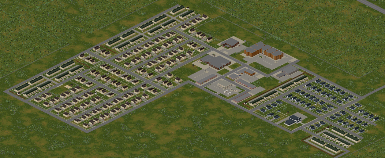
Rosewood
- Main article: Rosewood
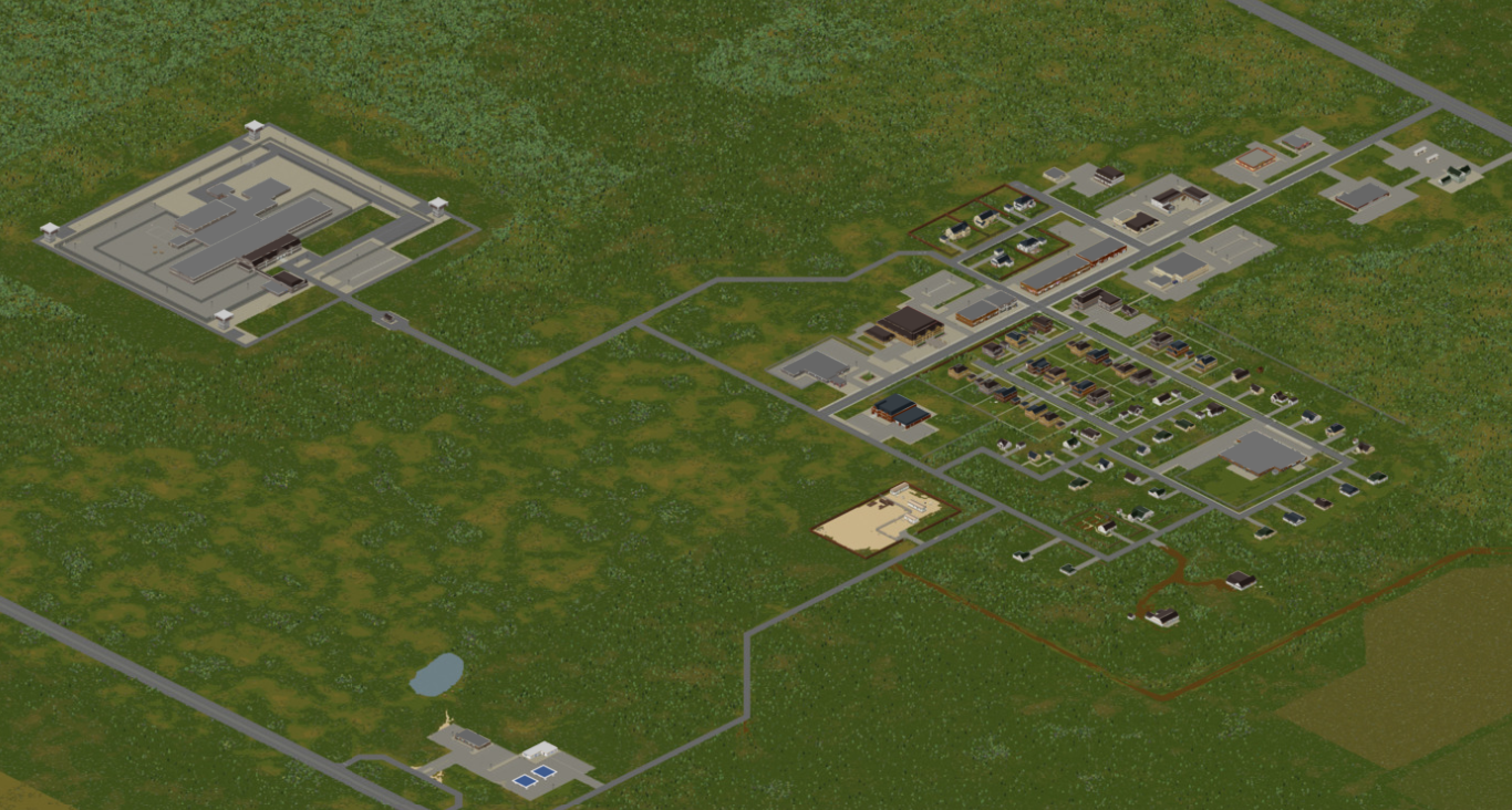
A newly-developed town with compact services and a nearby prison.
Some points of interest in town include:
West Point
- Main article: West Point
A large river-bound town north of Muldraugh with a clear town center and a close proximity to the Ohio River crossings.
Some points of interest in town include:
Valley Station
- Main article: Valley Station

A sparse town across the Ohio River whose main attraction is its sizeable mall.
Some points of interest in town include:
Louisville
- Main article: Louisville
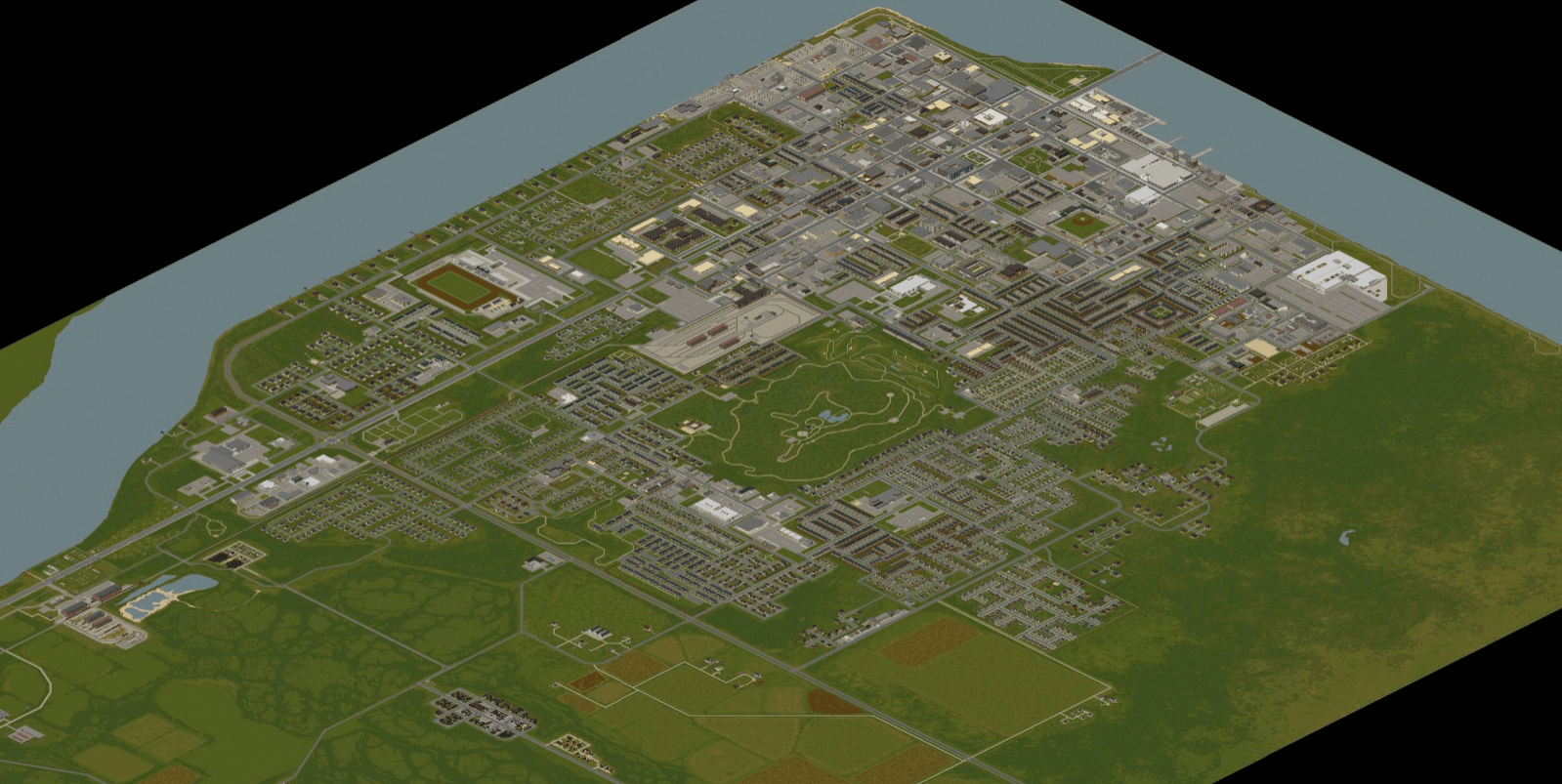
A large, densely populated metropolis across the Ohio River on the border of the Knox Exclusion Zone. Later designated part of the exclusion zone after being overrun. Most of the city's borders are still sealed off by fences constructed during the Knox Event.
Some points of interest in the city include:
- LBMW - Kentucky Radio
- LBMW Network
- St. Peregrin Hospital
- Louisville border camp
- Louisville Police Department and Detention Services
- Louisville Expo Center
- Spiffo's Headquarters
- Art Gallery of Louisville
- Fossoil Refinery
- Ready Prep Army Issue Surplus
- Louisville General Hospital
- Louisville Fire Department
- Louisville Train Station
- Louisville State University
- Medical Center
- The Grand Ohio Mall
- Fossoil Field
- Triple-N
March Ridge
- Main article: March Ridge
A gated military settlement made up of tenement buildings and surrounded by forest.
Some points of interest in town include:
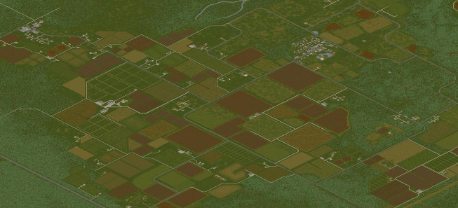
Fallas Lake
- Main article: Fallas Lake

A rural town surrounded by farmland in the center of Knox Country. Features an oddly shaped lake.
Points of interest in this town include:
- Farming & Rural Supply
- Doctor's office
- Police station
- Town hall
- E.P. Tools
Dixie Mobile Park
- Main article: Dixie Mobile Park

A trailer park which takes its name from the Dixie Highway on which it lies.
Points of interest in this settlement include:
Scenic Grove Mobile Park
- Main article: Scenic Grove Mobile Park

The Scenic Grove Mobile Park is a trailer park near Riverside. It also includes a small roadside rest stop.
Doe Valley
- Main article: Doe Valley
Doe Valley is a large area of Knox Country, being mostly farmland, small houses, and produce warehouses. There are low to no POI's in Doe Valley. Inside Doe Valley, there is a seperate town, that town being called "Jamieton". Doe Valley also encompasses Fallas Lake.
Abandoned town
- Main article: Abandoned town

The abandoned town, nicknamed Tanglewood by the community, is a dilapidated town, with a large factory nearby. All the houses and businesses are abandoned and in a very poor state except for a single home, which that house could be called the "trapper's house".
Fort Knox

Fort Knox is a location that is supposed to be added in a future patch, close to the release.
Trivia
- Knox Country was previously called Knox County, which was renamed in 2013 after the original map was scrapped and remade.