

Valley Station: Difference between revisions
m (fixed coordinates linking to Riverside) |
Traindudeo (talk | contribs) (updated the page) |
||
| Line 17: | Line 17: | ||
| coordinates = 12672x5718 | | coordinates = 12672x5718 | ||
}} | }} | ||
'''Valley Station''' is | '''Valley Station''' is in southern outskirts of [[Louisville, KY|Louisville]] in the state of Kentucky, in an area known as [[Knox Country]], and based on the real-life '''[https://en.wikipedia.org/wiki/Valley_Station,_Louisville Valley Station, KY]'''. '''Valley Station''' is located east on the Ohio River, north east most of [[Knox Country]] and south of [[Louisville, KY|Louisville]]. [[Dixie Hwy|Dixie Hwy (Route 31W)]] runs through west section of '''Valley Station'''. '''Valley Station''' also does include [[Crossroads Mall]]. | ||
{{Main|Crossroads Mall}} | |||
==Businesses and | __TOC__ | ||
==Businesses and Landmarks== | |||
===Food & Drink=== | |||
{| class="pztable sortable" style="width:40%" | |||
! style="width:40%" | Business | |||
! style="width:20%; text-align:center;" | Type | |||
! class="unsortable" style="width:30%" | Coordinates | |||
|- | |||
| [[Burgers]] | |||
| Fast Food | |||
| <span class="plainlinks">[https://map.projectzomboid.com/?#12545x5267 12545x5267]</span><br><span class="plainlinks">[https://map.projectzomboid.com/?#13965x4866 13965x4866]</span> | |||
|- | |||
| [[Cafe]] | |||
| Cafe | |||
| <span class="plainlinks">[https://map.projectzomboid.com/?13093x5450 13093x5450]</span> | |||
|- | |||
| [[Churus R Us]] | |||
| Ice Cream Parlor | |||
| <span class="plainlinks">[https://map.projectzomboid.com/?#13655x5780 13655x5780]</span> | |||
|- | |||
| [[Pile O’ Crepe]] | |||
| Restaurant | |||
| <span class="plainlinks">[https://map.projectzomboid.com/?#13601x5756 13601x5756]</span> | |||
|- | |||
| [[Restaurant]] | |||
| Restaurant | |||
| <span class="plainlinks">[https://map.projectzomboid.com/?#12743x5712 12743x5712]</span><br><span class="plainlinks">[https://map.projectzomboid.com/?#13058x5294 13058x5294]</span> | |||
|- | |||
| [[Sweet Eats!]] | |||
| Restaurant | |||
| <span class="plainlinks">[https://map.projectzomboid.com/?#3646x5669 3646x5669]</span> | |||
|- | |||
| [[The Straight Shooter]] | |||
| Bar | |||
| <span class="plainlinks">[https://map.projectzomboid.com/?#13006x5263 13006x5263]</span> | |||
|- | |||
| [[Yummmers]] | |||
| Restaurant | |||
| <span class="plainlinks">[https://map.projectzomboid.com/?#13572x5757 13572x5757]</span> | |||
|- | |||
|} | |||
===Hair & Beauty=== | |||
{| class="pztable sortable" style="width:40%" | |||
! style="width:40%" | Business | |||
! style="width:20%; text-align:center;" | Type | |||
! class="unsortable" style="width:30%" | Coordinates | |||
|- | |||
| [[Silken Belles]] | |||
| Hair Salon | |||
| <span class="plainlinks">[https://map.projectzomboid.com/?#13618x5668 13618x5668]</span> | |||
|- | |||
|} | |||
===Hotel/Motel=== | |||
{| class="pztable sortable" style="width:40%" | |||
! style="width:40%" | Business | |||
! style="width:20%; text-align:center;" | Type | |||
! class="unsortable" style="width:30%" | Coordinates | |||
|- | |||
| [[Guns-a-BlazINN]] | |||
| Hotel/Motel | |||
| <span class="plainlinks">[https://map.projectzomboid.com/?#13007x5323 13007x5323]</span> | |||
|- | |||
| [[Knob Creek Hunting Lodge]] | |||
| Lodge | |||
| <span class="plainlinks">[https://map.projectzomboid.com/?#13102x5302 13102x5302]</span> | |||
|- | |||
|} | |||
===Leisure=== | |||
{| class="pztable sortable" style="width:40%" | |||
! style="width:40%" | Business | |||
! style="width:20%; text-align:center;" | Type | |||
! class="unsortable" style="width:30%" | Coordinates | |||
|- | |||
| [[Dock]] | |||
| Dock | |||
| <span class="plainlinks">[https://map.projectzomboid.com/?#12481x5298 12481x5298]</span> | |||
|- | |||
| [[Park]] | |||
| Park | |||
| <span class="plainlinks">[https://map.projectzomboid.com/?#13825x5654 13825x5654]</span> | |||
|- | |||
|} | |||
===Retail & Stores=== | |||
{| class="pztable sortable" style="width:40%" | |||
! style="width:40%" | Business | |||
! style="width:20%; text-align:center;" | Type | |||
! class="unsortable" style="width:30%" | Coordinates | |||
|- | |||
| [[Beer + Liquor]] | |||
| Retail Store | |||
| <span class="plainlinks">[https://map.projectzomboid.com/?#12718x5062 12718x5062]</span> | |||
|- | |||
| [[Dressed To The 90s]] | |||
| Clothing Store | |||
| <span class="plainlinks">[https://map.projectzomboid.com/?#13685x5669 13685x5669]</span> | |||
|- | |||
| [[Food Market]] | |||
| Grocery Store | |||
| <span class="plainlinks">[https://map.projectzomboid.com/?#12570x5729 12570x5729]</span><br><span class="plainlinks">[https://map.projectzomboid.com/?#13058x5294 13058x5294]</span> | |||
|- | |||
| [[Grocery Store]] | |||
| Grocery Store | |||
| <span class="plainlinks">[https://map.projectzomboid.com/?#12627x5326 12627x5326]</span> | |||
|- | |||
| [[Morris’ Bait Shop]] | |||
| Fishing Shop | |||
| <span class="plainlinks">[https://map.projectzomboid.com/?#12538x5288 12538x5288]</span> | |||
|- | |||
| [[Worm Of Books]] | |||
| Book Store | |||
| <span class="plainlinks">[https://map.projectzomboid.com/?#13605x5670 13605x5670]</span> | |||
|- | |||
| [[Zippee Mart]] | |||
| Convenience Store | |||
| <span class="plainlinks">[https://map.projectzomboid.com/?#13655x5767 13655x5767]</span> | |||
|- | |||
|} | |||
===Services=== | |||
{| class="pztable sortable" style="width:40%" | |||
! style="width:40%" | Business | |||
! style="width:20%; text-align:center;" | Type | |||
! class="unsortable" style="width:30%" | Coordinates | |||
|- | |||
| [[Cemetery]] | |||
| Cemetery | |||
| <span class="plainlinks">[https://map.projectzomboid.com/?#14567x4974 14567x4974]</span> | |||
|- | |||
| [[Eternal Light Chapel]] | |||
| Church | |||
| <span class="plainlinks">[https://map.projectzomboid.com/?#14548x4975 14548x4975]</span> | |||
|- | |||
| [[Fun-2-3 Childcare]] | |||
| Daycare | |||
| <span class="plainlinks">[https://map.projectzomboid.com/?#13587x5669 13587x5669]</span> | |||
|- | |||
| [[J. Tinsley Elementary School]] | |||
| Elementary School | |||
| <span class="plainlinks">[https://map.projectzomboid.com/?#12858x4856 12858x4856]</span> | |||
|- | |||
| [[Knox Bank]] | |||
| Bank | |||
| <span class="plainlinks">[https://map.projectzomboid.com/?#13655x5743 13655x5743]</span> | |||
|- | |||
| [[Rest Stop]] | |||
| Rest Stop | |||
| <span class="plainlinks">[https://map.projectzomboid.com/?#12733x5772 12733x5772]</span> | |||
|- | |||
| [[Sacred Flame Church]] | |||
| Church | |||
| <span class="plainlinks">[https://map.projectzomboid.com/?#12854x4955 12854x4955]</span> | |||
|- | |||
|} | |||
===Utilities=== | |||
{| class="pztable sortable" style="width:40%" | |||
! style="width:40%" | Business | |||
! style="width:20%; text-align:center;" | Type | |||
! class="unsortable" style="width:30%" | Coordinates | |||
|- | |||
| [[Filling station#Gas 2 Go|Gas 2 Go]] | |||
| Filling Station | |||
| <span class="plainlinks">[https://map.projectzomboid.com/?#13734x5658 13734x5658]</span> | |||
|- | |||
| [[Filling station#Ruby Gas|Ruby Gas]] | |||
| Filling Station | |||
| <span class="plainlinks">[https://map.projectzomboid.com/?#12743x5046 12743x5046]</span> | |||
|- | |||
|} | |||
===Industrial=== | |||
{| class="pztable sortable" style="width:40%" | |||
! style="width:40%" | Business | |||
! style="width:20%; text-align:center;" | Type | |||
! class="unsortable" style="width:30%" | Coordinates | |||
|- | |||
| [[Construction Site]] | |||
| Residential/Industrial | |||
| <span class="plainlinks">[https://map.projectzomboid.com/?#14098x5419 14098x5419]</span><br><span class="plainlinks">[https://map.projectzomboid.com/?#14195x5766 14195x5766]</span> | |||
|- | |||
| [[McCoy Logging Co.]] | |||
| Industrial/Trailer | |||
| <span class="plainlinks">[https://map.projectzomboid.com/?#14252x5739 14252x5739]</span> | |||
|- | |||
|} | |||
===Other=== | |||
{| class="pztable sortable" style="width:40%" | |||
! style="width:40%" | Business | |||
! style="width:20%; text-align:center;" | Type | |||
! class="unsortable" style="width:30%" | Coordinates | |||
|- | |||
| [[Drag Strip]] | |||
| Drag Strip | |||
| <span class="plainlinks">[https://map.projectzomboid.com/?#12870x6358 12870x6358]</span> | |||
|- | |||
| [[Junk Baron]] | |||
| Junk Yard | |||
| <span class="plainlinks">[https://map.projectzomboid.com/?#12582x5387 12582x5387]</span> | |||
|- | |||
| [[StarEPlex]] | |||
| Cinema Theater | |||
| <span class="plainlinks">[https://map.projectzomboid.com/?#13605x5885 13605x5885]</span> | |||
|- | |||
| [[Storage Lot]] | |||
| Storage | |||
| <span class="plainlinks">[https://map.projectzomboid.com/?#12960x4878 12960x4878]</span> | |||
|- | |||
| [[Warehouse]] | |||
| Warehouse | |||
| <span class="plainlinks">[https://map.projectzomboid.com/?#12622x4714 12622x4714]</span> | |||
|- | |||
| [[Valu In$urance]] | |||
| Office | |||
| <span class="plainlinks">[https://map.projectzomboid.com/?#13666x5671 13666x5671]</span> | |||
|- | |||
|} | |||
==Gallery== | ==Gallery== | ||
Revision as of 07:42, 31 December 2021
The Game World > Locations > Valley Station

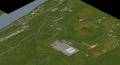
Valley Station is in southern outskirts of Louisville in the state of Kentucky, in an area known as Knox Country, and based on the real-life Valley Station, KY. Valley Station is located east on the Ohio River, north east most of Knox Country and south of Louisville. Dixie Hwy (Route 31W) runs through west section of Valley Station. Valley Station also does include Crossroads Mall.
- Main article: Crossroads Mall
Businesses and Landmarks
Food & Drink
| Business | Type | Coordinates |
|---|---|---|
| Burgers | Fast Food | 12545x5267 13965x4866 |
| Cafe (Valley Station) | Cafe | 13093x5450 |
| Churus R Us | Ice Cream Parlor | 13655x5780 |
| Pile o' Crepe | Restaurant | 13601x5756 |
| Restaurant | Restaurant | 12743x5712 13058x5294 |
| Sweet Eats! | Restaurant | 3646x5669 |
| The Straight Shooter | Bar | 13006x5263 |
| Yummmers | Restaurant | 13572x5757 |
Hair & Beauty
| Business | Type | Coordinates |
|---|---|---|
| Silken Belles | Hair Salon | 13618x5668 |
Hotel/Motel
| Business | Type | Coordinates |
|---|---|---|
| Guns-a-BlazINN | Hotel/Motel | 13007x5323 |
| Knob Creek Hunting Lodge | Lodge | 13102x5302 |
Leisure
| Business | Type | Coordinates |
|---|---|---|
| Dock | Dock | 12481x5298 |
| Park | Park | 13825x5654 |
Retail & Stores
| Business | Type | Coordinates |
|---|---|---|
| Beer + Liquor | Retail Store | 12718x5062 |
| Dressed To The 90s | Clothing Store | 13685x5669 |
| Food Market | Grocery Store | 12570x5729 13058x5294 |
| Grocery Store | Grocery Store | 12627x5326 |
| Morris’ Bait Shop | Fishing Shop | 12538x5288 |
| Worm Of Books | Book Store | 13605x5670 |
| Zippee Mart | Convenience Store | 13655x5767 |
Services
| Business | Type | Coordinates |
|---|---|---|
| Cemetery | Cemetery | 14567x4974 |
| Eternal Light Chapel | Church | 14548x4975 |
| Fun-2-3 Childcare | Daycare | 13587x5669 |
| J. Tinsley Elementary School | Elementary School | 12858x4856 |
| Knox Bank | Bank | 13655x5743 |
| Rest Stop | Rest Stop | 12733x5772 |
| Sacred Flame Church | Church | 12854x4955 |
Utilities
| Business | Type | Coordinates |
|---|---|---|
| Gas 2 Go | Filling Station | 13734x5658 |
| Ruby Gas | Filling Station | 12743x5046 |
Industrial
| Business | Type | Coordinates |
|---|---|---|
| Construction site | Residential/Industrial | 14098x5419 14195x5766 |
| McCoy Logging Co. | Industrial/Trailer | 14252x5739 |
Other
| Business | Type | Coordinates |
|---|---|---|
| Drag Strip | Drag Strip | 12870x6358 |
| Junk Baron | Junk Yard | 12582x5387 |
| Star-E-Plex | Cinema Theater | 13605x5885 |
| Storage Lot | Storage | 12960x4878 |
| Warehouse | Warehouse | 12622x4714 |
| ValuInsurance | Office | 13666x5671 |
Gallery
In-game Valley Station
